Alta Via 2 – Trekking in the Dolomites – Cicerone
37.95$
Alta Via 2 – Trekking in the Dolomites – Cicerone ISBN 9781786310972
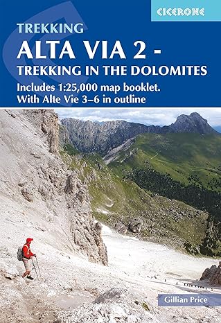
Guidebook with separate 1:25,000 map booklet to Alta Via 2, a long-distance trail through the western Dolomites in Italy. This challenging hut-to-hut trek involves steep, technical terrain and aided and exposed sections, and is suitable for walkers with good fitness and experience of high-altitude routes.
- Includes separate map booklet featuring 1:25,000 Kompass mapping for the entire AV2 route
- Totalling 108 miles (174km) in length, AV2 is usually walked in 13 daily stages of 5–14 miles (8–22km)
- Clear route descriptions with 1:75,000 maps and elevation profiles, and side-routes to explore nearby summits and points of interest
- Advice on walking three- to six-day sections of the route for walkers who prefer not to tackle AV2 in its entirety
- Starting from Bressanone, the north–south AV2 route crosses Passo Gardena, Passo Pordoi, Malga Ciapela and Passo San Pellegrino, nearing San Martino di Castrozza and Fiera di Primiero before finishing at Feltre
- Also contains overview maps and route descriptions for Alta Via 3, 4, 5 and 6, four harder and more remote north–south routes in the central and eastern Dolomites
- Short rope and karabiners helpful for some sections, although not compulsory
- GPX files available for download
English
Pages: 136
Dimensions: 11 X 17 X 1 cm
Publication: 2022