Additional information
| Map Type | Nautical atlas |
|---|---|
| Region |
139.95$
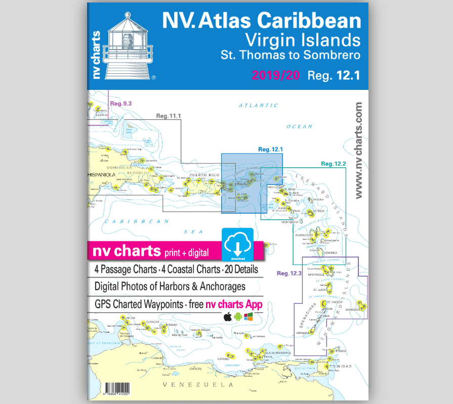
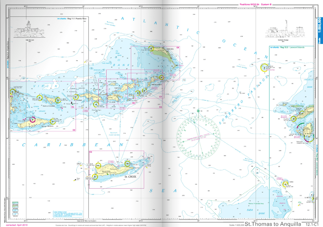
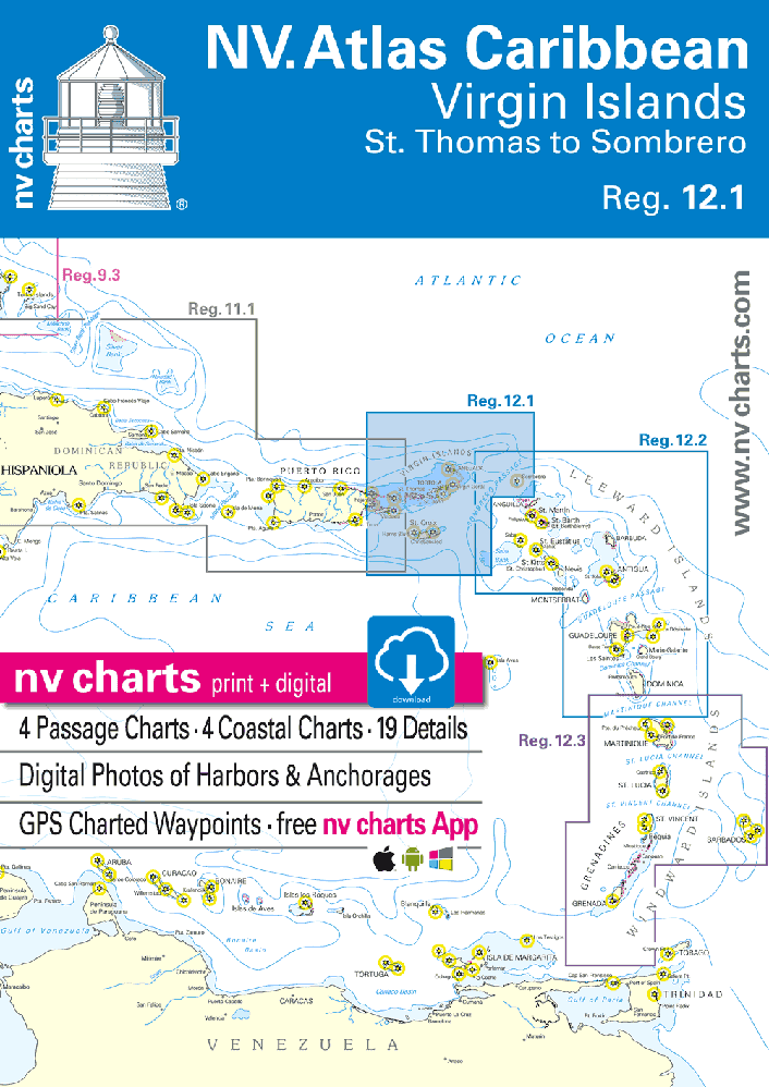
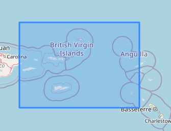
With NV Charts Caribbean 12.1, you have the perfect companion for sailing the Virgin Islands from St. Thomas to Sombrero. Thanks to the clear layout, you’ll quickly find approaches, harbors, and anchorages, and be alerted to key navigational details—also visible in the NV Charts app. The atlas impresses with its optimal dimensions and well-balanced chart segments.
The Virgin Islands, divided into the U.S. Virgin Islands and the British Virgin Islands, are a sailor’s paradise. With steady trade winds, clear blue waters, and a remarkable diversity of islands, they are one of the world’s most popular sailing destinations.
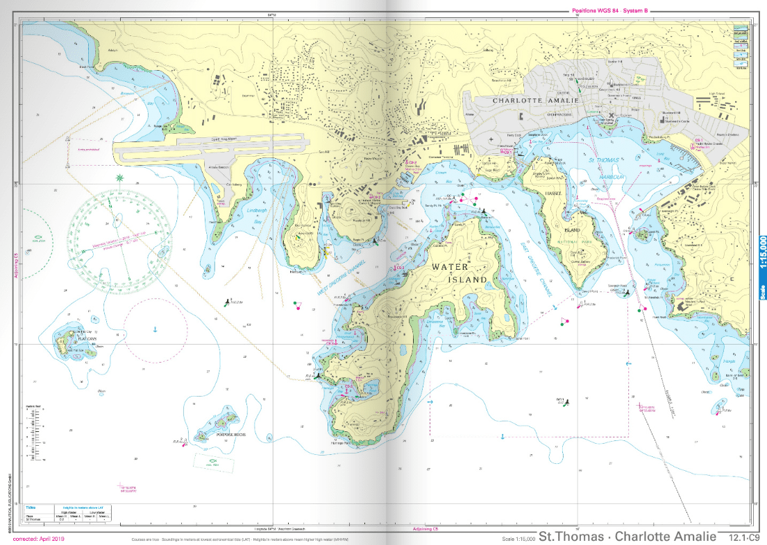
On St. Thomas, the historic city of Charlotte Amalie is well worth a visit. Known for its colonial architecture, charming shops, and panoramic views from Paradise Point.
The island of Jost Van Dyke is a favorite among sailors, offering three fantastic anchorages: White Bay, Great Harbour, and Little Harbour. Named after Dutch pirate Joost van Dyke, the island has only about 300 inhabitants.
Sombrero Island is the furthest island included in this chart coverage and belongs to the British territory of Anguilla. This uninhabited island is home to many rare animal species and, at just 1.5 km long, can be explored quickly.
The Virgin Islands region is known for its numerous reefs and shallow areas. Careful navigation and up-to-date nautical charts are essential.
Tip: With NV Charts Caribbean 12.2 and 12.3, you can also explore the Windward and Leeward Islands further east. NV Charts Caribbean 11.1 covers the islands west of the Spanish Virgin Islands, reaching to the Dominican Republic.
4 overview charts
4 area charts
19 detailed charts
Digital charts for navigation software and the NV Charts app
365-day license
In English
Fully compliant with current legal requirements for onboard paper nautical charts
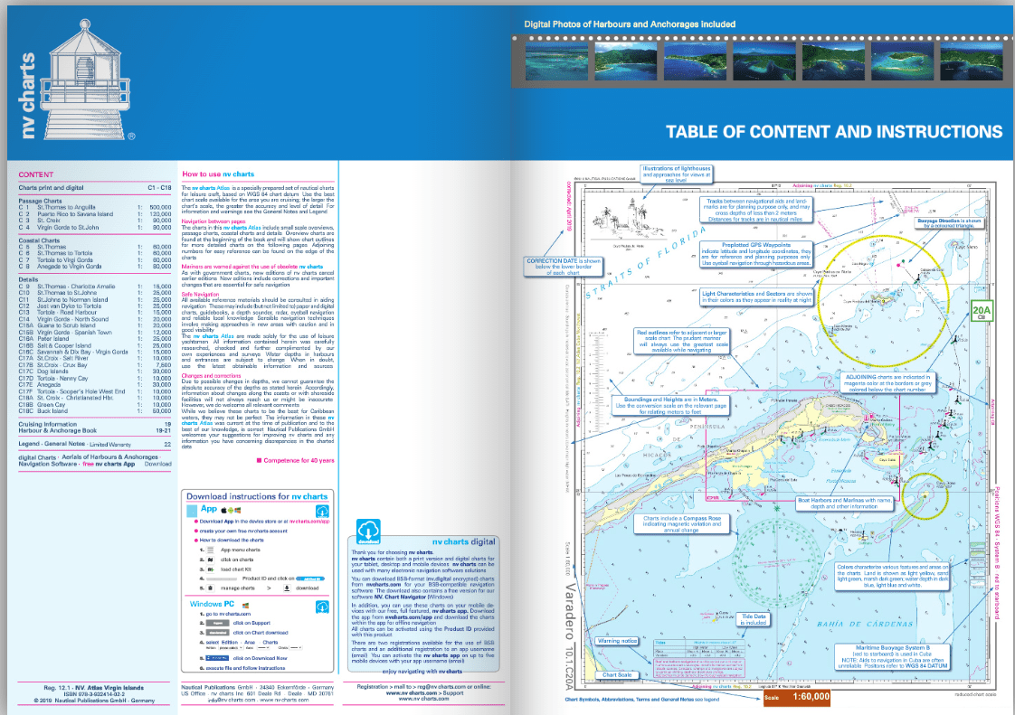
NV Atlas Chart Format:
Practical and handy atlas format, A2 when open, A3 when closed, center-stapled – ideal for charting with a navigation triangle.
NV Charts App:
Includes access code for digital nautical charts of the purchased area with a 365-day license. Allows for offline navigation in the app on iOS, Android, PC, Mac, or via web browser. Includes a comprehensive harbor guide.
Extremely Detailed:
Charts are based on official survey data and our own surveys, offering exceptional detail outside of main channels.
Optimized for recreational boating.
Flexible automatic routing
Satellite overlays
Augmented reality
VMG (Velocity Made Good)
BoatView harbor guide
Track recording
AIS connectivity and much more
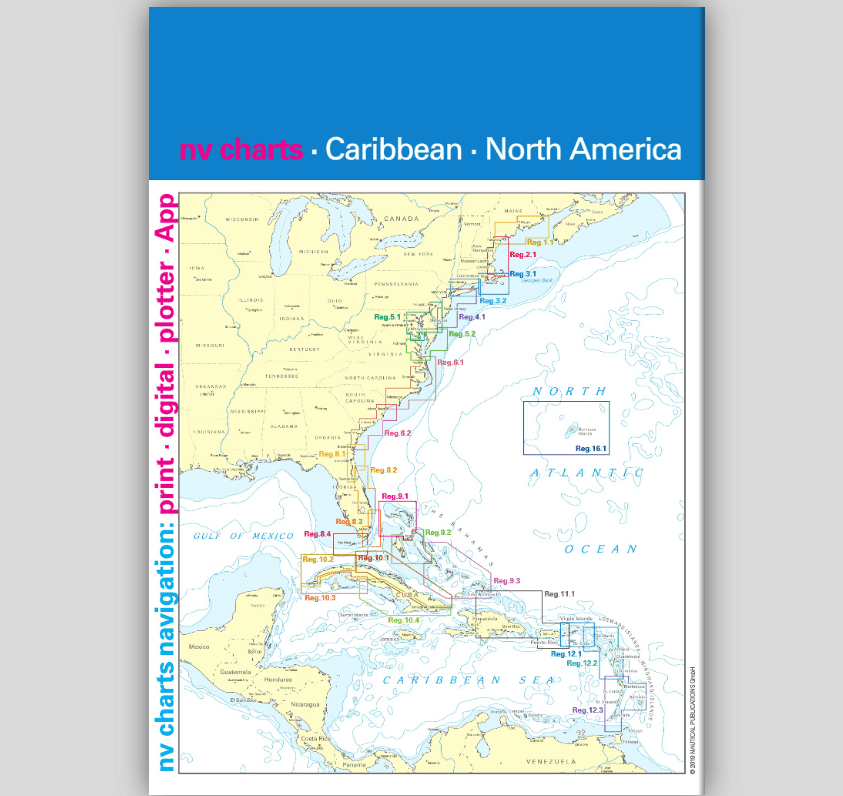
C1 St. Thomas to Anguilla – 1:500,000
C2 Puerto Rico to Savana Island – 1:120,000
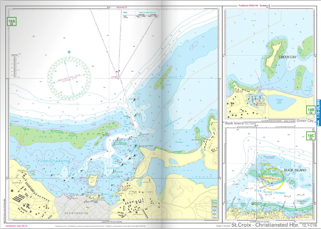
C3 St. Croix – 1:90,000
C4 Virgin Gorda to St. John – 1:90,000
C5 St. Thomas – 1:60,000
C6 St. Thomas to Tortola – 1:60,000
C7 Tortola to Virgin Gorda – 1:60,000
C8 Anegada to Virgin Gorda – 1:80,000
C21A Bahía de Mayagüez – Puerto Rico – 1:40,000
C21B Bahía de Boquerón – Puerto Rico – 1:40,000
C22 San Juan – Puerto Rico – 1:20,000
C23A Parguera – Puerto Rico – 1:40,000
C23B Puerto Ferro to Puerto Real – 1:30,000
C23C Ens. Honda Approach – Isla de Culebra – 1:20,000
C24A Bahía de Fajardo – Puerto Rico – 1:15,000
C24B Puerto del Rey – Puerto Rico – 1:10,000
C24C Isabel Segunda – Isla de Vieques – 1:25,000
C24D Naguabo – Puerto Rico – 1:40,000
C24E Punta Arenas – Isla de Vieques – 1:35,000
C24F Palmas del Mar – Puerto Rico – 1:10,000
C25A Luperón – Dominican Republic – 1:12,000
C25B Puerto Plata – Dominican Republic – 1:15,000
C25C Marina Puerto Bahía – Dominican Republic – 1:5,000
C25D Ocean World Marina – Dominican Republic – 1:6,000
C25E Marina Cap Cana – Dominican Republic – 1:15,000
Legend – General Notes – p.26
| Map Type | Nautical atlas |
|---|---|
| Region |