- Maps
- Travel
- Marine
- Outdoor
- Canadian Parks & Regions
- American National Parks and Long Trails
- Europe Maps & Guides
- International Outdoor Maps & Guides
- Saint-Jacques-de-Compostelle
- Outdoor Magazines
- Topographic maps for France
- Initiation Guides for Outdoor, Fishing, Hunting & Survival
- Bike
- Compass
- Swiss Knives
- Flora and Fauna
- Star Finder
- GPS
- Globes
- Kidz
- Gift Ideas
- Blog
- Contact us
- Français

Services
OUR LAMINATION SERVICE
A laminated card will last longer; it will resist wind, weather, tearing, and normal wear and tear. A plastic thickness of 1.7 mm allows users to roll and fold their documents without damaging them.
Two different machines allow us to laminate all types of documents up to 48 inches in width. This service is available at all times on a 27-inch wide machine and at intervals of twice a week on a 48-inch wide machine.
Most store-bought cards can be laminated. We also laminate any document that customers bring in that may have been purchased elsewhere.
We calculate the cost of lamination per linear inch, that is, by measuring the length of the document. Special and predetermined rates are applied for certain products:
- Topographic maps: 12$
- Marine charts: 15$
- Aeronautical charts: 15$
- Standard size road maps: 15$
- Large format road maps: 20$
For any lamination not priced in-store, expect a cost of $0.60 / linear inch + taxes.
OUR MOUNTING SERVICE
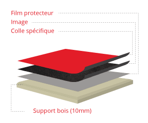
Any document, whether purchased in-store or not, can be mounted on a wood or laminated foam panel. Mounting on a panel results in a final product with much more character and durability.
Three types of wood mounting are available: flush mount, floater (mini-backing), and ⅜ inch plaque (presswood).
The document is vacuum heat glued onto a 3mm or 10mm thick wood plaque. Simultaneously, a perfectly transparent and invisible protective plastic film is applied, giving the frame a washable, UV-resistant, and anti-glare surface. The matte finish provides a glare-free frame. The final appearance is slightly textured, enhancing all images.

Mountings on laminated foam panels have the advantage of being less expensive and lighter than wood. They also allow customers to pin the map with tacks to identify specific locations. The lamination can be matte or glossy, allowing writing and erasing on the document with permanent or non-permanent markers.
Please allow one to two weeks for any mounting.
OUR CUSTOM AND PERSONALIZED MAP SERVICE
Do you have specific needs that no map meets? We can design maps for you, within our limits. Of course, a few days’ lead time is to be expected. Any size is possible.
Here are some examples of custom maps we offer:
- Regional maps of Quebec: we regularly design maps of specific administrative regions or larger territories to meet the needs of organizations or companies wanting to clearly identify municipalities and the road network of their activity area. These maps come laminated or not.
- Local and urban maps: Urban areas including Montreal or any other major Quebec cities can be mapped at a local level, showing the entire road network.
- Electoral district maps: Any political party knows that door-to-door campaigning is crucial for winning elections. To clearly identify the boundaries of your constituency and divide tasks among volunteers, there’s nothing better than a large wall map.
- Topographic maps: Are you going hiking along a specific trail? We can design a map showing contour lines, the hydrographic network, and georeferenced details of your trail. Have you bought a cottage and want to know all the details of your immediate region? Nothing is better for planning your excursions or hikes than a topographic map showing all the geographical entities listed, down to marshes, intermittent streams, and footpaths.
HUNTING AREA MAPS
If you engage in fine hunting and move around your hunting zone, you need a custom map. If the area is in a wildlife reserve, we can also display the limits of the area according to government data.
For moose hunting, we also offer the possibility of designing a custom map showing the best hunting sectors. The data is generated by an algorithm analyzing the provincial government’s ecoforestry maps based on criteria from the famous hunter Michel Breton. You will find well-identified resting areas and feeding zones, classified according to the richness of the environment and the likelihood of encountering animal activity.
OUR AERIAL PHOTOGRAPHY RESEARCH SERVICE
Did you know that aerial photos taken by plane are more precise than those taken by satellite? For any engineering, legal analysis, or urban planning needs, these photos will provide you with excellent work tools.
We are the exclusive reseller of geomatic products (photos and orthophotos) from the Communauté Métropolitaine de Montréal (CMM). We also offer the service of research and resale for photos offered by the provincial government of Quebec and the federal government of Canada.
The available photos start from the 1930s for most sectors of Quebec and Canada and are also available up to the current year of research, depending on the sector searched. Historical photos are excellent sources of information to see the evolution of a specific sector over the years, whether for legal reasons or land analysis.
To start the photo research process, just write to us via the contact form specifying your needs, either by mentioning the years searched and the desired zone. An image showing the limits of the sector, an address, a lot number, or a shapefile (kml or other) speeds up the research process. We then send you a quote with the search results. You select the photos you want to buy and after payment, we send you the photos in digital or paper format.
Research fees apply in most requests.